Listen to
M+, Hong Kong, © Ian Lambot. Photo: M+, Hong Kong
PRESENTER:
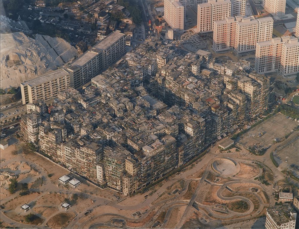
This aerial view of Kowloon Walled City was taken by Ian Lambot in the 1980s.
Kowloon Walled City was originally a Qing Dynasty military outpost. When the Kowloon Peninsula was ceded to Britain in 1860, disputes over the site’s sovereignty raged, and the area ultimately went ungoverned by any power for decades. Due to this lack of management, Kowloon Walled City organically evolved into a unique and dense urban structure.
Chan Cheung Chuen lived in the walled city, and for him, it’s full of childhood memories.
CHAN CHEUNG CHUEN:
When I was little I lived in Tung Tau Estate, which isn’t part of the walled city. I first went there with classmates to visit another friend who lived within the walled city, and we’d play Hide and Seek. I later moved to the walled city myself after getting married to start my family. The walled city was like this perplexing maze; I loved the exploration and adventure. The dark corners and the intertwined streets were perfect for hide and seek.
PRESENTER:
From the outside, the walled city seems dense, impenetrable. As Chan tells it though, it was a place of incredible spatial complexity. Chan’s own work relates to mechanical drawing, so when the walled city was about to be demolished, he drew his own map of the walled city.
CHAN CHEUNG CHUEN:
The main things to map were the intertwined streets, and the upper-level walkways connecting different buildings. They meant you could move easily from the inside of one building to another. This, to me, is the uniqueness of this map.
PRESENTER:
This density and close physical proximity meant that unique connections built up among the walled city’s residents.
CHAN CHEUNG CHUEN:
For instance, in the case of a fire, people could alert each other; they could keep watch and help each other thanks to our sheer physical proximity. There were many couples in the Kaifong—or Neighbourhood Welfare Association—who met in the walled city. And when you were cooking dinner, you could just open the window and ask your neighbour, ‘Hey do you have some soy sauce?’ Swapping ingredients through windows like this happened regularly.
When it came to crime, it was hard to for anyone to burgle anyone in the walled city, as a single shout for help would alert everyone nearby immediately. Plus, the thief would have to be as familiar with the walled city as me, able to draw a map of all the roads, otherwise they’d end up stuck in a cul-de-sac! I sometimes thought it was safer in the walled city than outside.
PRESENTER:
We hope these stories, and Ian Lambot’s aerial photograph, have made you reflect on how our living spaces impact on our daily interactions and connections with those around us.
NARRATOR:
Aerial view from the south-west of the Kowloon Walled City, Hong Kong, is a colour photograph taken by Ian Lambot in 1989. It was then inkjet-printed and mounted on a Dibond® aluminium composite panel in 2013. The landscape photograph measures 91.7 centimetres high and 120 centimetres wide.
Taken from a bird’s eye view at sunset, the photo depicts hundreds of densely packed buildings in the Kowloon Walled City. Next to these unregulated buildings are public housing structures that have an orderly layout, and the Carpenter Road Park that’s mostly unvegetated.
Placed at the centre of the photo, the Walled City takes up approximately 60 percent of the image. It’s situated in the urban area next to a hill, constituting one big rectangular city block. The buildings have discordant heights and all of them are built around a rectangular central area, where the Former Yamen Building of Kowloon Walled City is located. Being one of the shortest buildings in the Walled City, the Former Yamen Building was surrounded by the other taller structures, forming an area that looks like a rectangular hole punched into the city block. The few hundreds of buildings are built back-to-back, with no obvious space among them. As a whole, the Walled City has worn out exterior walls and cluttered rooftops with diverse types of roofing.
From the north-west to the east of the Walled City, are modern public housing estates that consist of around six residential blocks. Some of them consist of elongated buildings that are joined at the sides, while the others consist of two parallel, staggered buildings that are joined near the ends. Some of them appear to be newly built while the others seem to have been inhabited for some years. The blocks are eight to twelve storeys high. The windows of all apartments are open to a broad view and most of them face south-east.
From the west to the south-east of the Walled City, is the Carpenter Road Park with public open spaces, a hard-surface soccer pitch, and basketball courts that are under construction. The public open spaces are mud grounds without vegetation, through which run sinuous paths with very few pedestrians. It’s sunset, and the sun shines from the left of the photo and illuminates the Walled City’s south-west exterior. The higher storeys and rooftops of the buildings inside bathe in the fading sunlight. The setting sun casts light on the Walled City, and the densely packed buildings seem to form a hill that in turn casts faint shadows on the public housing estates.